Variables and Data
The variables are organized in an abstract way, independently of the way they are persisted.
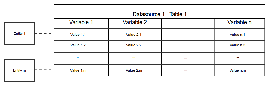
The following diagram presents a ‘traditional’ view of what is a table:
the ‘columns’ are the variables,
the ‘rows’ are the value sets for each entity,
the ‘cells’ are the variable entity values.
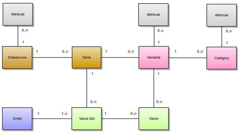
The following diagram shows the relationships between the different concepts:
Variables
Variables and Categories
A variable describes a set of values. The values of a variable are all of the same type. Possible value types are:
integer
decimal
text
binary
locale
boolean
datetime
date
point
linestring
polygon
A variable is about an entity, i.e. all the values for a variable are from the same entity type. Possible entity types are:
Participant
Instrument
…
A category describe some of the possible values of a variable. A category is associated to one and only one variable.
Datasources and Tables
A variable is in one and only one table.
A table has several variables and is in one and only one datasource.
A datasource has several tables. A datasource is not a database: it can be persisted in a database, using different schema. It can also be persisted in a file in xml or Excel formats. It is important to understand that Opal separates the formal description of the variables from the way they are persisted. This gives to Opal a lot of versatility.
Attributes
Datasources, variables and categories have attributes. These attributes provide additional meta-information. An attribute is made of:
a namespace (optional),
a name (required),
a locale (optional), that specifies in which language is the attribute value,
a value (required even if null).
Example of a variable asked_age which has the following attributes:
Name |
Locale |
Value |
|---|---|---|
label |
en |
What is your age ? |
label |
fr |
Quel est votre age ? |
questionnaire |
IdentificationQuestionnaire |
|
page |
P1 |
The variable asked_age has also some categories (with their attributes):
Name |
Attributes |
|---|---|
888 |
label:en=Don’t know
label:fr=Ne sait pas
|
999 |
label:en=Prefer not to answer
label:en=Préfère ne pas répondre
|
Fully Qualified Names
Each of these elements has a short name. A fully qualified name will identify them uniquely:
Datasource fully qualified name: <datasource_name>
Table fully qualified name: <datasource_name>.<table_name>
Variable fully qualified name: <datasource_name>.<table_name>:<variable_name>
The fully qualified name is useful for disambiguation.
Following the example of the asked_age variable, its fully qualified name could be: opal-data.IdentificationQuestionnaire:asked_age
Derived Variables
A derived variable is a variable which values are computed using a script. This script is expressed using the Magma Javascript API.
Views
Opal deals with variables and values in tables. Views are here to:
define a subset of a table, both in terms of variables and values,
define a subset of many tables in terms of variables and values,
define #Derived Variables that are to be resolved against ‘real’ ones.
These virtual tables are then manipulated just like standard tables (for instance they can be copied to a datasource).
Given table Table1:
ID |
Var1 |
Var2 |
Var3 |
|---|---|---|---|
1 |
Value 1.1 |
Value 2.1 |
Value 3.1 |
2 |
Value 1.2 |
Value 2.2 |
Value 3.2 |
3 |
Value 1.3 |
Value 2.3 |
Value 3.3 |
A view can be defined so that the resulting ‘table’ may be View1:
ID |
Var1 |
Var3 |
|---|---|---|
1 |
Value 1.1 |
Value 3.1 |
3 |
Value 1.3 |
Value 3.3 |
or View2:
ID |
DerivedVar = function(Var1, Var2) |
|---|---|
1 |
function(Value1.1, Value2.1) |
3 |
function(Value1.3, Value2.3) |
Given Table1 above and the following table Table2:
ID |
VarA |
VarB |
VarC |
|---|---|---|---|
100 |
Value A.100 |
Value B.100 |
Value C.100 |
200 |
Value A.200 |
Value B.200 |
Value C.200 |
300 |
Value A.300 |
Value B.300 |
Value C.300 |
A view can also be a combination or a ‘join’ of both tables, as in View3:
ID |
Var1 |
Var3 |
VarA |
VarC |
|---|---|---|---|---|
1 |
Value 1.1 |
Value 3.1 |
||
3 |
Value 1.3 |
Value 3.3 |
||
100 |
Value A.100 |
Value C.100 |
||
300 |
Value A.300 |
Value C.300 |
Data
Entities
The entities can be of different types:
Participant (most common)
Instrument (provided by Onyx)
Workstation (provided by Onyx)
… (any that might fit your needs)
Each entity has a unique identifier. An entity can have several value sets, but only one value set for a particular table.
Value Types
The following table gives more information about the textual representation of a value, given a value type:
Value Type |
Value as a String |
|---|---|
|
The string value must all be decimal digits, except that the first character may be an ASCII minus sign ‘-’ to indicate a negative value. The resulting integer has radix 10 and the supported range is [-2 63, 2 63-1]. |
|
As described by Java Double documentation. |
|
As-is. |
|
Base64 encoded. |
|
String representation of a locale is <language>[_<country>[_<variant>]] (for instance en, en_CA etc.) where:
language: lowercase two-letter ISO-639 code.
country: uppercase two-letter ISO-3166 code.
variant: vendor specific code, see Java Locale.
|
|
True value if is equal, ignoring case, to the string “true”. |
|
Date times are represented in ISO_8601 format: “yyyy-MM-dd’T’HH:mm:ss.SSSZ”
Supported input formats are (four digits year is required):
yyyy-MM-dd’T’HH:mm:ss.SSSZ
yyyy-MM-dd’T’HH:mm:ssZ
yyyy-MM-dd’T’HH:mmZ
yyyy-MM-dd’T’HH:mm:ss.SSSzzz
yyyy-MM-dd HH:mm:ss
yyyy/MM/dd HH:mm:ss
yyyy.MM.dd HH:mm:ss
yyyy MM dd HH:mm:ss
yyyy-MM-dd HH:mm
yyyy/MM/dd HH:mm
yyyy.MM.dd HH:mm
yyyy MM dd HH:mm
|
|
Dates are represented in ISO_8601 format: “yyyy-MM-dd”
Supported input formats are (four digits year is required):
yyyy-MM-dd
yyyy/MM/dd
yyyy.MM.dd
yyyy MM dd
dd-MM-yyyy
dd/MM/yyyy
dd.MM.yyyy
dd MM yyyy
|
|
Point coordinates (longitude, latitude).
Supported input formats are:
GeoJSON
JSON
Google Map
# GeoJSON
{type: “Point”, coordinates: [-71.34, 41.12]}
# GeoJSON coordinates only: [lon,lat]
[-71.34, 41.12]
# JSON (different flavours of keys)
{“lat” : 41.12,”lon” : -71.34}
{“lat” : 41.12,”lng” : -71.34}
{“latitude” : 41.12,”longitude” : -71.34}
{“lt” : 41.12,”lg” : -71.34}
# String, comma separated latitude and longitude (Google map like): lat,lon
41.12,-71.34
|
|
Array of point coordinates.
Supported input format is GeoJSON:
# GeoJSON
{type: “LineString”, coordinates: [[22.2,44.1],[33.4,55.3],[32.12,44]]}
# GeoJSON coordinates only
[[22.2,44.1],[33.4,55.3],[32.12,44]]
|
|
Array of shapes. A shape is a list of points. The last point must be equal to the first point.
Supported input format is GeoJSON:
# GeoJSON
{type: “Polygon”, coordinates: [[ [100.0, 0.0], [101.0, 0.0], [101.0, 1.0], [100.0, 1.0], [100.0, 0.0] ]]}
# GeoJSON coordinates only: one shape polygon
[
[ [100.0, 0.0], [101.0, 0.0], [101.0, 1.0], [100.0, 1.0], [100.0, 0.0] ]
]
# GeoJSON coordinates only: polygon with outter and inner shapes
[
[ [100.0, 0.0], [101.0, 0.0], [101.0, 1.0], [100.0, 1.0], [100.0, 0.0] ],
[ [100.2, 0.2], [100.8, 0.2], [100.8, 0.8], [100.2, 0.8], [100.2, 0.2] ]
]
|
Value Sets and Values
A value is associated to a variable and is part of a value set. Each value set is for a particular entity and a particular table. An entity has a maximum of one value set in one table.
A value is always associated with a type and a data (or a sequence of data if the variable is repeatable).